UN Adopts Africa-Led Proposal for New World Map Showing the Continent’s True Size
The United Nations has overwhelmingly backed an Africa-led proposal encouraging the use of a new world map that more accurately represents the true size of continents, especially Africa.
The United Nations General Assembly has adopted a landmark resolution promoting a new world map designed to correct one of geography’s longest-standing distortions: the shrinking of Africa’s true size on traditional maps. The proposal, spearheaded by Togo on behalf of the African Union, received overwhelming support from member states, with 164 countries voting in favour, six abstaining and only the United States voting against it.
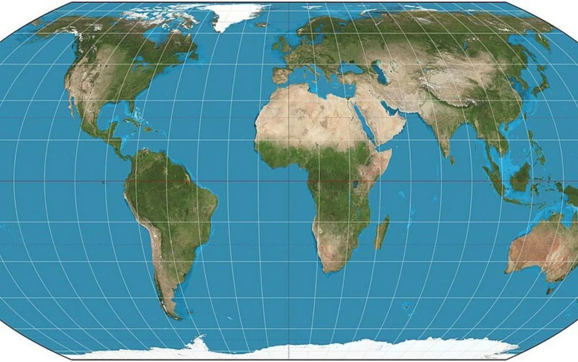
Rather than replacing every existing map, the resolution encourages governments, schools, international organizations and technology companies to adopt the Equal Earth projection for educational and public reference purposes. The measure is non-binding but represents a significant shift in how the world’s geography may be presented in classrooms, atlases and digital mapping platforms.
For centuries, the Mercator projection has been the dominant world map despite its well-documented distortions. Created in 1569 for maritime navigation, it enlarges landmasses near the poles while reducing the apparent size of regions closer to the equator. One of its most striking inaccuracies is that Greenland appears roughly comparable to Africa, even though Africa is about 14 times larger in reality.
Togo’s Foreign Minister, Robert Dussey, described the initiative as part of a broader effort to address historical and colonial-era biases embedded in global cartography. Supporters argue that maps do more than show geography, they influence how people perceive the political, economic and cultural importance of nations and continents.
The United States opposed the resolution, arguing that the proposal introduced an ideological dimension into what it viewed as a technical cartographic issue. However, supporters countered that the Equal Earth projection is not intended to eliminate the Mercator map, which remains valuable for navigation, but to promote more accurate representations of land area in education and public communication.
Developed in 2018 by cartographers Bojan Šavrič, Bernhard Jenny and Tom Patterson, the Equal Earth projection preserves the relative size of continents while maintaining a visually familiar world map. Its creators designed it specifically to provide a fairer alternative to projections that exaggerate the Global North and diminish equatorial regions.
The resolution is expected to encourage gradual adoption rather than immediate replacement. Togo has already announced plans to update school geography materials, while discussions are expected with the African Union and major mapping and technology companies about broader implementation.
Beyond cartography, the vote carries powerful symbolic weight. For many African nations, it represents an effort to reshape global narratives by ensuring the continent is portrayed not as a diminished landmass, but in its true geographic scale, an acknowledgment that how the world is mapped can also influence how it is understood.